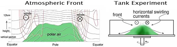
In the atmosphere, the transition between warm air in equatorial regions and cold polar air (shaded green in the figure, bottom left) is not gradual, but often occurs abruptly in mid-latitudes where equatorial and polar air masses meet. This transition region of sharp temperature gradient is known as the Polar Front. Weather is often associated with storms growing on the Polar Front.
In this project we study fronts in the laboratory and explore them using real-time atmospheric data – see intro.pdf and intro_slides.
A rotating tank in which two bodies of water of differing densities are brought together can be used to study analogues of atmospheric fronts in the laboratory. Dense, salty water at the center of the tank (shaded green in figure, bottom right) can be thought to represent cold polar air, and the freshwater that surrounds it, warm tropical air.